Introduction
Over the last few months there have been questions raised by owners regarding what considerations have been given in the TK14 and Te Tumu planning to date for:
1. Sea Level Rise (SLR)
2. Liquefaction
3. Natural Hazards
In response:
Natural Hazards Investigations
Over the last five-plus years there have been extensive technical investigations and reporting into the following natural hazards for the Te Tumu Urban Growth Area (including TK14 block):
1. Liquefaction & Lateral Spread
2. Tsunami
3. Coastal Erosion
4. Coastal Inundation
5. Flooding (Papamoa Stormwater Catchment)
Each of these investigations and reports has:
1. Incorporated Sea Level Rise (SLR) into the technical investigations
Note: The SLR levels incorporated in the investigations and reports generally sit within the medium confidence SLR Projections to 2150 as recently released in the NZ Sea Rise Project.
Click on the link here: https://searise.takiwa.co/
2. Determined that the risks to urban development within the Te Tumu Urban Growth Area are low under the Bay of Plenty Regional Council Regional Policy Statement (RPS) or can be designed to be mitigated to a low level of risk.
The key outcomes and SLR considerations for the above Natural Hazards are as follows:
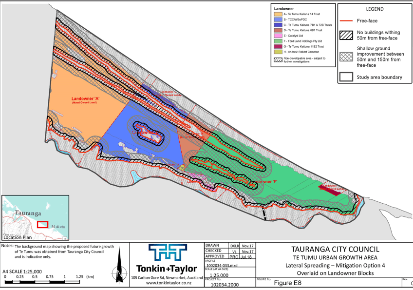
Liquefaction & Lateral Spread
Liquefaction was modelled and mapped for 500, 1,000 and 3,030-year Annual Recurrence Intervals respectively, including an allowance for sea-level rise to 2130.
The assessment shows the majority of the development site is susceptible to liquefaction (i.e. minor to moderate land damage) for earthquake events of these likelihoods. The eastern Landowner parcels are unlikely to experience liquefaction induced land damage (none to minor land damage).
The assessment analysed the liquefaction risk and evaluates levels of foundation design as possible mitigation options (i.e. slab on grade, TC2, TC3).
The assessment results show the risk is low for the majority of foundation options. TC2 and TC3 foundation types result in low liquefaction risk for all landowner parcel blocks. Therefore, the natural hazard risk from liquefaction can be considered to be low if this mitigation measure is actioned.
We note the low-risk outcome is limited to one and two-level buildings only. Buildings greater than two levels will require site-specific assessments as is normally the case.
See Map below: Tonkin & Taylor Lateral Spreading, Mitigation Option 4 Map
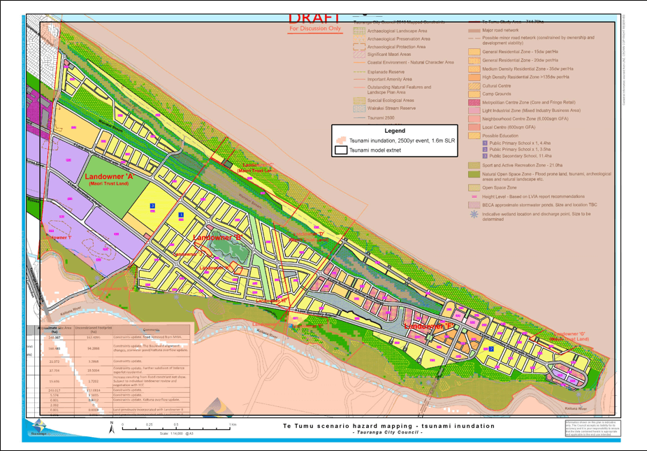
Tsunami
Tsunami inundation was modelled and mapped for 500, 1,000 and 2,500-year Annual Recurrence Intervals, including an allowance for sea-level rise to 2130.
The modelling results map minimal inundation across this site for tsunami events at these likelihoods. Minor inundation occurs along the Wairakei Stream and in some isolated areas on the periphery of the site along the Kaituna River.
The risk assessment was undertaken for each of the nine landowner parcels based on consequences to buildings and health and safety. Eight of the landowner parcels (i.e. natural hazard zones) resulted in low risk. The eastern landowner parcel resulted in a medium risk based on a moderate consequence level for health and safety.
Medium risk is required to be reduced to low risk for a new development proposal in accordance with RPS Policy NH 38. The report presents a range of options that can reduce the risk to low by mitigating the health and safety consequence. Considering the majority of the site is elevated above the modelled tsunami inundation levels, evacuation to safe ground is an accepted mitigation resulting in a low risk. Therefore, clear tsunami evacuation zones and routes should be a requirement of this development.
TCC Map showing Tsunami Inundation in a 2,500-year event with 1.6m SLR. This is based on the Tonkin & Taylor Tsunami Assessment Report for Te Tumu.
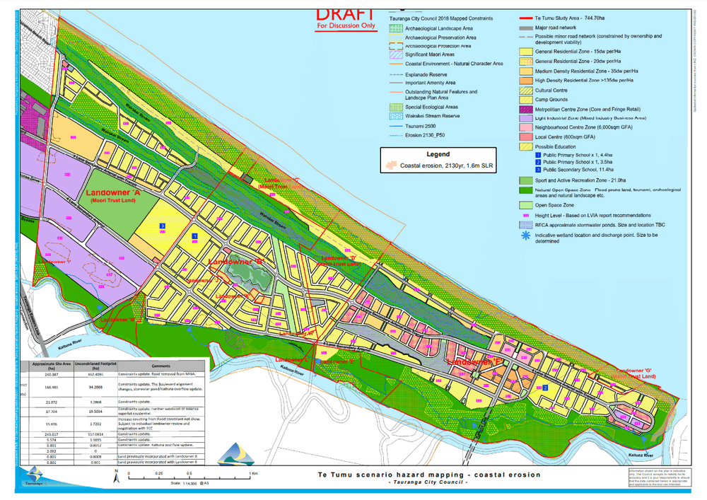
Coastal Erosion
Coastal erosion was modelled and mapped for 50% and 5% exceedance probability (EP) likelihoods (likely and very unlikely respectively), including an allowance for sea-level rise to 2130. For example, the 50% EP coastal erosion hazard zone has a 50% chance of being exceeded by the year 2130.
The assessment shows the development site is not subject to coastal erosion for either of the two likelihoods by the 2130 timeframe. Therefore, the natural hazard risk from coastal erosion is considered to be low.
TCC Map showing Coastal Erosion at 2130 with a 1.6m SLR. This is based on the NIWA Coastal Erosion Assessment Report for Te Tumu.
Coastal Inundation
Coastal inundation from storm surge and wave setup was modelled and mapped 50, 100 and 500-year Annual Recurrence Intervals, including an allowance for sea-level rise to 2130.
The assessment shows the development site is not subject to coastal inundation for events of these likelihoods. Therefore, the natural hazard risk from coastal inundation is considered to be low. However, the natural hazard upstream from the coast from the conjunctive risk from coastal inundation (with the effects upon upstream water levels) and intense rainfall and river flooding is yet to be assessed.
The site was stress-tested against a higher sea level rise scenario, which resulted in some inundation along proposed roads and around proposed stormwater ponds. The inundation pathway is from the Kaituna River and no dune overtopping or inundation is expected from the open coast side.
Flooding (Papamoa Stormwater Catchment)
The predicted design flood level of between 4.6 mRL to 4.7mRL in the Wairakei Stream in Te Tumu is based on the 100-year Annual Recurrence Interval flood level of the fully developed Te Tumu Growth Area and incorporated a 2130 SLR of 1.6mRL.
As set out in the Beca Stormwater Strategy, stormwater management design parameters and requirements for building platforms, pipe infrastructure and flow paths have been based on this.
See below the following Beca Plans:
Proposed Stormwater System Overflow – No 4284941-AC-001 RevA
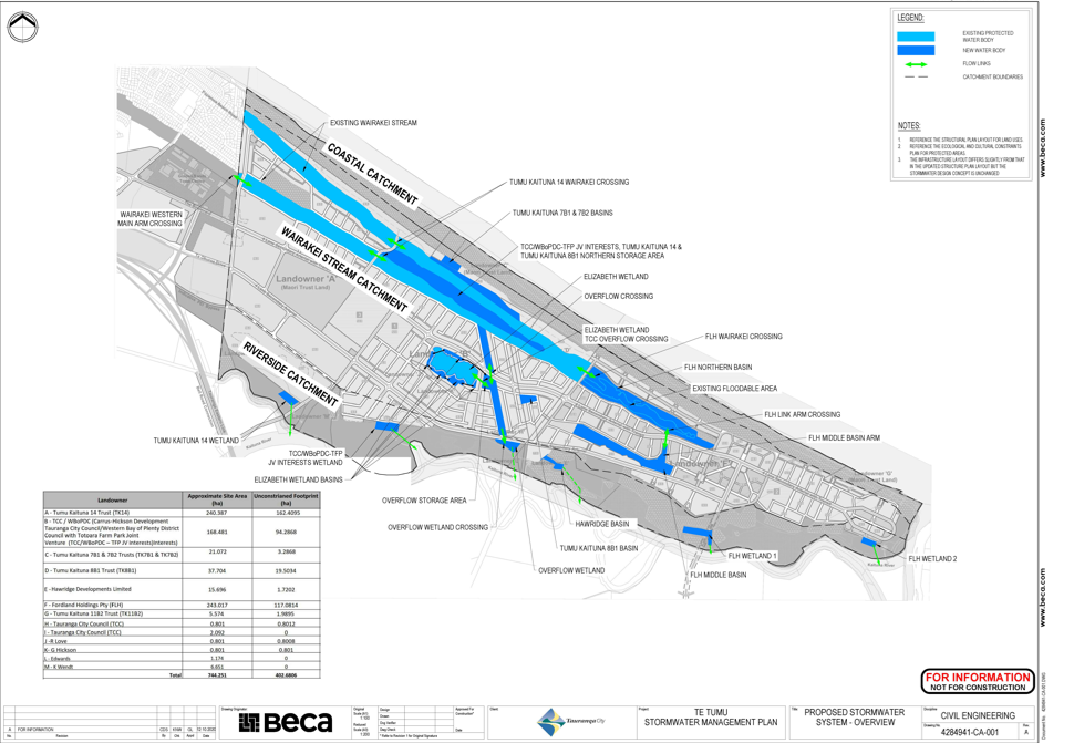
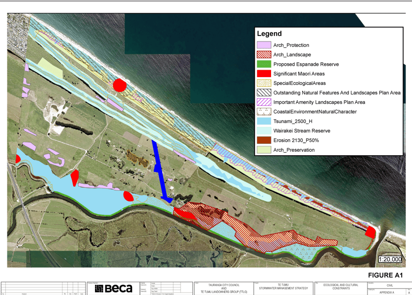
Figure A1- Ecological and Cultural Restraints: showing Flooding, Erosion and Tsunami impacts/overlays
References:
References:
- BoPRC – TCC Letter Te Tumu New Community Planning – Natural Hazard Risk Assessment, dated 18 December 2018
- Tonkin & Taylor Report Te Tumu Natural Hazard Risk Assessment – Liquefaction, Job No 1002034.2000 dated June 2018
- Tonkin & Taylor ReporVersion 2 – 21 November 2017 – Coastal Erosion
- T+T (2020) – Te Tumu Coastal Erosion Hazard Assessment Update – 1.6m SLR (1)
- NIWA Report Coastal Inundation Mapping at Te Tumu, Bay of Plenty, dated August 2017.
- Beca Report Te Tumu Urban Growth Area – Stormwater Management Strategy, 2 November 2020
If you have any further questions you can fill out our survey here or contact us here.